
Professional Survey Engineering Consultancy L.L.C. is one of the best land survey and geophysical survey companies in UAE offering cost-effective topographic survey services to a wide range of projects in UAE and middle east regions for more than 10 years. We have an expert team of engineering surveyors and modern equipment to conduct topographic surveys.
Our surveyors are devoted to producing first-class Topographical Surveys to provide you with accurate measurements of your land.
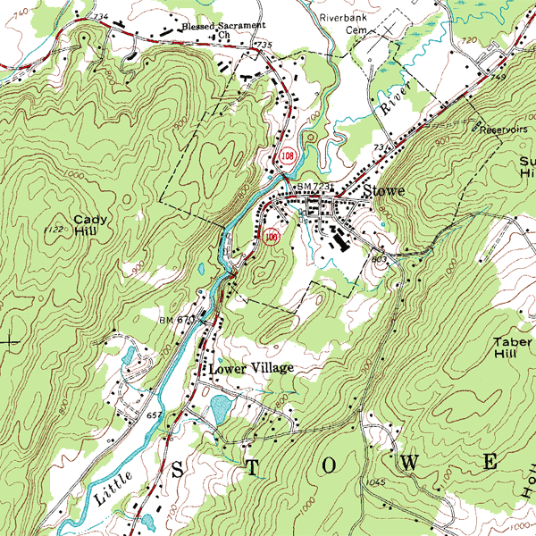
A topographical survey, sometimes also called as a land survey provides an accurate representation of natural and man-made features within a specified area. These surveys are undertaken using precision equipment and the latest technology.
Topographical surveys have a variety of uses including clearly showing land boundaries, flood risk modeling, building planning, utility mapping, and building alterations and designs.
With high quality instruments, and professional staff, our land survey services can be an efficient solution to each and every project. If you need a professional land surveyor, then look no further.
We are an award winning land surveying firm, providing services across the UAE.
We specialize in construction layouts, topographical surveys, demarcation and boundary surveys, as-built surveys, measured building surveys and provide dedicated mapping services.
Why you need a Topographical Survey?
If you are looking to develop your land, then an accurate survey of the levels and features is essential.
Without reliable measured information, it can be easy for mistakes to occur. This could result in wasted time on site for contractors, delays in planning applications, and in extreme cases, you may find that what
you planned to build, isn’t possible. These mistakes, usually lead to additional costs or lost income. This may lead to exceeding your budget.
An accurate and well detailed Land Survey will pay for itself many times over throughout your project and can heavily reduce wasted time and costs.
Topographic surveys are used to determine and plan features such as drainage ditches, grading, or other features, using the natural landscape as the basis for such improvements. Engaging a professional surveyor to conduct a topographic survey prior to a real estate transaction or the commencement of a construction project will ensure that the land’s features will be suitable for its intended use. In addition, a topographic survey can provide valuable insight into how a site’s previous or current use affected the land, enabling better planning for future use.
Topographic surveying can play a crucial role in securing project success.
One of the most important functions of topographic survey is to identify areas where construction may not be possible or where grading will be required in order to make it possible. A topographic survey provides architects and builders with all of the information they need to determine how the land will have to be shaped and moulded to provide a suitable base for the planned construction.
After the initial project completion, a topographic survey can also be used as the basis for a variety of subsequent plans and designs. For these reasons, it is crucial that a topographic survey is carried out by professional land surveyors who have the knowledge, tools and training to do it right. An accurate and detailed initial topographic survey will help ensure that the project is completed without costly or time-consuming surprises.
How Professional Surveys create a reliable and accurate Topographical Survey
Our Topographical surveys will locate all relevant visible site features. The specification can be adapted to suit your specific needs, to ensure that no detail you require is missed.
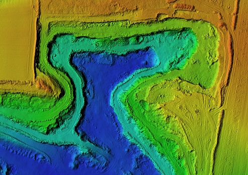
By utilizing the latest technology for our land surveys such as robotic equipment, laser scanners, and drones, you can be sure that the information is captured in the most efficient way, delivering the best possible value to your project.
Services and deliverables tailored for your project
Land Surveys or Topographical Surveys:
- Topographical / Land Survey – 2D or 3D presented in CAD and PDF formats.
- River Cross-section data – presented in CAD and flood modeler formats.
- Property Boundary Surveys.
- Utility and drainage connectivity surveys (GPR & PAS128) These provide a topographical survey with underground services context – 2D or 3D presented in CAD and PDF formats.
Why Choose Us for Topographic Surveys?
- Expert and experienced team of surveyors.
- Use of latest technology and modern equipments.
- Fast and accurate survey.
- We work with great attention to details.
- Reliable and reasonable services.