
Global Presence
- Professional Survey Engineering Consultancy LLC
- P.O. Box: 132972, Abu Dhabi – UAE
- Email: info@professional-surveys.com
Tel: +971 2 5501090Fax: +971 2 5501090Mob: +971 50 3213022
- Enquire Now
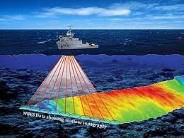
Hydrographic Survey
Professional Surveys is a trusted leading hydrographic and bathymetric survey companies in UAE.
Our surveyors have access to a wide range of hydrographic survey sensors, platforms, state-of-the-art technology and software, enabling us to deliver a unique, tailored data solution to your specific needs. Survey systems are selected based on the scope of work, water depth, operating frequency, range from shore, accuracy requirements, seabed conditions, and size of vessel.
We advise you on the best approach to meet your project’s quality, accuracy, time and cost goals.
We have a qualified team of hydrographic surveyors who work in smart and efficient way through planning, processing and reporting process.
Whether the project is an inland river or waterway, a port or harbour, or an offshore site, we have the expertise and experience to satisfy the client’s project demands from within our own equipment inventory, vessel fleet and professional staff resources.
We are able to provide solutions that meet client’s hydrographic requirements, from the land-sea boundary to the full ocean depth, using acoustic, optical and remote sensing technology.
Hydrographic Survey Services We Offer
- Multibeam Hydrographic Survey
- 360 Degree Acoustic Imaging
- Side Scan Sonar Imaging
- 3D Multibeam Scanning Sonar
Why choose Professional Surveys ?
- Specialists in all forms of hydrographic surveying
- A quality assured and totally professional service
- Over 10+ years’ experience in carrying out Bathymetric Surveys
- Comprehensive stock of the latest navigational and echosounding equipment
Different Methods we use for Hydrographic/Bathymetric Surveys:
- Multi-beam surveying
- Acoustic Doppler Current Profiler (ADCP)
- Sub-bottom profilers
- Ecomapper Autonomous Underwater Vehicle
Equipments Used for Hydrographic Survey
- Multibeam Sonars
- Side Scan Sonars
- Lidar
- Laser Scanners
- Sound Speed Profilers
- GPS
Project Deliverables
- standard mapping and charting
- point clouds
- structural modelling
- digital terrain modelling
- BIM level modelling etc.
Request a proposal