Global Presence
- Professional Survey Engineering Consultancy LLC
- P.O. Box: 132972, Abu Dhabi – UAE
- Email: info@professional-surveys.com
Tel: +971 2 5501090Fax: +971 2 5501090Mob: +971 50 3213022
- Enquire Now
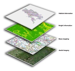
GIS software adds intelligence to spatial data, whether the data is generated in the field with GPS or remotely with lidar and photogrammetry. You can enter raw data, measurements, and field sketches directly into the GIS, enabling you to efficiently manage your data in a geodatabase with other spatial information.
You can use GIS technology for collecting, importing, converting, and storing spatial measurement and computational fabrics. You can integrate computations, such as COGO and traverse least squares, and preexisting networks as well as import spatial data feature classes and relationships.With GIS software, you can bring data straight from the field into a geodatabase in a seamless workflow and take GIS data back into the field via a data collector or laptop computer. GIS software is customized to best meet your needs by optimizing functionality needed to complete a job.