
Global Presence
- Professional Survey Engineering Consultancy LLC
- P.O. Box: 132972, Abu Dhabi – UAE
- Email: info@professional-surveys.com
Tel: +971 2 5501090Fax: +971 2 5501090Mob: +971 50 3213022
- Enquire Now
Radiodetection techniques are unable to detect non-metallic buried services such as plastic water and gas pipes, fibre-optics and drainage pipes that we cannot introduce a sonde into. To overcome this potentially hazardous situation, we combine the use of Radiodetection with Ground Penetrating Radar (GPR). GPR survey can prove effective at locating archaeological features underneath a wide range of surfaces that cannot be surveyed by any other geophysical technique. Good results can be obtained underneath concrete, stone, tarmac and through grass and soil. In addition, an indication of depth can be provided which may prove highly useful where intrusive work is required.
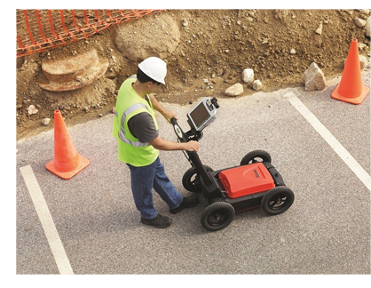 GPR survey records reflected radio waves that are pulsed into the ground as the radar antenna is dragged along the ground surface. Changes in the ground make-up, such as from soil to stone, provide conditions where some of the transmitted energy is returned to the surface. In this way, subsurface features can be mapped.Careful timing of the returned radio waves along with calculations of the ground’s dielectric constant can allow an estimate of depth to be made.
The transmitted radio energy is very wide in bandwidth but peaks at the resonant frequency of the antenna. As resolution is a function of the transmitted wavelength, a 400MHz system will have a higher resolution than a 200MHz system; however, the lower frequency system may have superior penetration which may be critical in certain conditions. 200 and 400MHz systems are typical of those used for archaeological prospection.
Damp clay soils may present problems at times and it is not uncommon for conditions to be so poor that no penetration below a few centimetres is possible. It’s also worth noting that rarely can gpr be used to locate graves. Exceptions exist, particularly if disturbance is recent or if there are buried voids or associated structural features.